Master thesis / publication (2018)
Turbulence Ahead - A 3D Web-Based Aviation Weather Visualizer
Technologies used
JavaScript • ArcGIS Pro • ArcGIS Online • R
To conclude my studies in Geomatics Engineering, I worked for my master thesis on a prototype for a 3D web-based aviation weather visualizer that was developed in collaboration with Swiss International Airlines at ETH Zürich. This project was also published and presented at an international conference for user interfaces and software technology.
Project Overview
more about the project
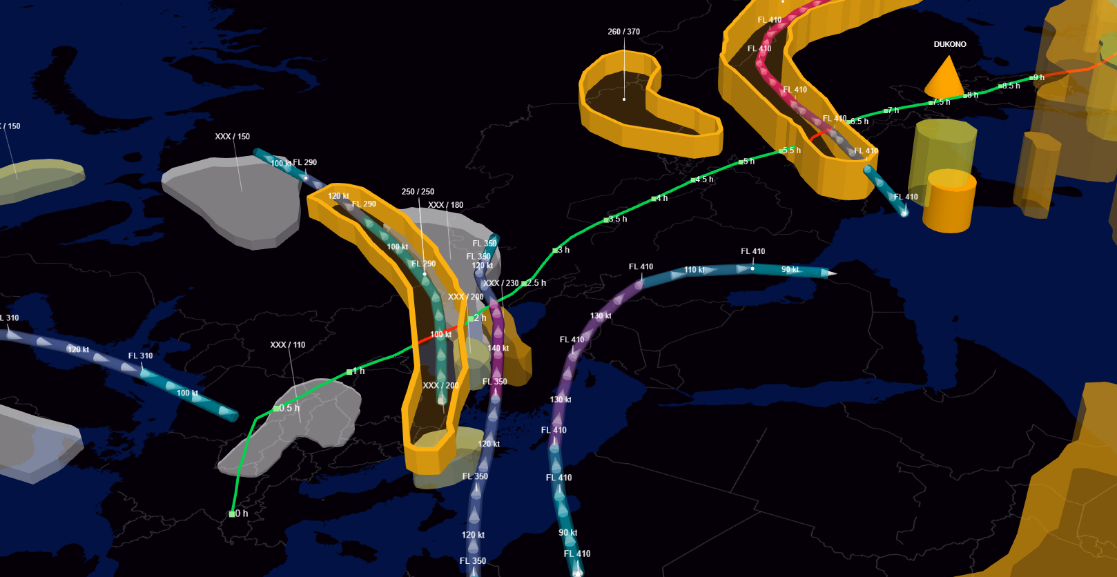
Turbulence is still a major threat in commercial aviation. Whereas severe aircraft accidents have been reduced in general in the last decades, the number of injuries and fatalities caused by turbulence is still rising. Current aviation weather products are not able to provide a holistic and intuitive view of the overall weather situation for pilots, especially in terms of turbulence forecasts. Technological advancements in the field of 3D graphics on the web as well as streaming services have opened up new possibilities for data visualizations of large amounts of weather-related data. However, to date, no 3D web-based application for forecast weather data has been introduced or evaluated in the context of commercial aviation.
In the course of this master thesis, an interactive 3D prototype was developed with a user-centered design approach that displays the weather objects from the Significant Weather Charts (SWC). Included in the Operational Flight Program (OFP), SWCs are forecast maps that are issued by the World Area Forecast Center (WAFC) four times a day and are used by pilots to prepare for flights.
For the development of the application, the different weather objects depicted on the SWC map (e.g., jet streams) were projected into the third dimension by applying appropriate 3D web symbology. The 3D application was developed by using the ArcGIS API for JavaScript, a 3D mapping framework that allows efficient streaming and displaying large amounts of 3D data. The design and functionality of the application were developed and evaluated in a pilot study with subject matter experts.
In a second step, the 3D prototype was compared to the 2D SWC map in an online user study. In total, 64 commercial aviation pilots from Swiss International Air Lines participated in the online survey. The major findings of the evaluation of the user study include significant improvements in cognitive load (-18.3\%), usability (+29.4\%), and spatial awareness (+24.4\%) when using the 3D application. A further contribution of this thesis is a novel similarity measure for spatial configurations of aviation weather data that was introduced in order to assess spatial awareness in a drawing task in the user study.
The project has also been published as a research paper at UIST'18. The paper can be downloaded here.
More information about this project can be found on this ArcGIS Blogpost
interested in learning more?